| Edited by Jaakko Jalas, Juha Suominen, Raino Lampinen (since vol. 11) and Arto Kurtto (since vol. 12)on the basis of team-work of European botanists. Atlas Florae Europaeae shows the European distribution of species and subspecies. The ranges have been mapped with the aid of a grid of 50-km squares - a total of 4 419 squares for the whole of Europe. The notes on the maps give important synonyms, data on taxonomy and nomenclature, important additions and corrections (mainly complementing Flora Europaea) and references to maps of the total range. The most recent literature available has been consulted. The area mapped is that of Flora Europaea. The Azores and Spitsbergen appear as insets in the printed maps. The mapping symbols are different for native occurrences, introductions (established aliens), unknown or uncertain status, extinct, probably extinct and uncertain records. Within the same square, native occurrences are given preference over introductions, extant over extinct, certain over uncertain. | |
| Published volumes, and their distribution. Twelve volumes of Atlas Florae Europaeae have already been published, altogether 2039 pages and 3270 maps. | Committee for Mapping the Flora of Europe: members. Member list sorted by country. Includes street and e-mail addresses. |
| AFE grid system. | Mapping territories. Country or territory abbreviations used in AFE. There are some differences compared to the abbreviations of Flora Europaea (see the list of Geographical codes used in Flora Europaea at RBG Edinburgh). |
| Universal Transverse Mercator (UTM) and the Military Grid Reference System (MGRS). | Mapping symbols. Symbols used in AFE, their short description, some statistics. |
| Chorological Problems in the European Flora meeting. The VIII Meeting of Committee for Mapping for the Flora of Europe was held in Helsinki 8-10 August 1997. | Sample account with maps. Genus Neslia (AFE vol. 11, 1996), with two scanned maps. |
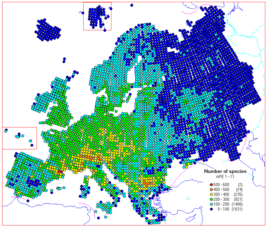
| Statistics from AFE volumes 1 - 11. Some summary maps for families, genera and species. The 2927 maps have been scanned and processed with custom software to determine dot locations, and the distribution data is now maintained in a database. | Cartographic links for botanists. Links to Internet sites with online plant distribution maps, and/or information on plant distribution mapping projects, and links to computerized mapping in general. |
| Searchable Flora Europaea database at RBG Edinburgh. | The Atlas Florae Europaeae Database. The distribution maps published in Atlas Florae Europaeae 1 - 11 as a digital database. |
Number of species/grid cell,
calculated from the distribution maps in AFE 1 - 11 (covering c.
20% of European vascular plants)
 Home Page of the Botanical Museum, Finnish Museum of
Natural History
Home Page of the Botanical Museum, Finnish Museum of
Natural History
Updated 2 June, 1999 by Raino Lampinen