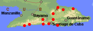
Range of Pinus cubensis (1). Basemap from Expedia Maps.
Common Names
Taxonomic notes
Syn: Pinus occidentalis Swartz var. cubensis (Grisebach) Silba 1984; Pinus wrightii Engelmann 1880; Pinus maestrensis Bisse 1975; Pinus occidentalis var. maestrensis (Bisse) Silba 1990 (1).Description
See (1).Range
E Cuba: Sierra Maestra and Sierra de Nipe, E into the highlands terminating the eastern part of the island, also in foothills and coastal pine barrens at 100-900(-1200) m. Typical substrates include serpentine or other ferruginous soils ("Nipe latosol" or"Nipe clay"); coastal stands on alluvium. It usually forms pure, open stands and is often (as with almost all pines) invasive after disturbance. Climate wet/dry seasonal, with up to 1800 mm rainfall in the wet summer (1).It is the only pine native to E Cuba (see below); no pines occur naturally between E Cuba and Pinar del Rio at the W end of the island (1).
Big Tree
Oldest
Dendrochronology
Ethnobotany
Locally exploited for its timber (1).Observations
Remarks
Citations
(1) Farjon & Styles 1997.[Pinus] [Pinaceae] [home]
This page is from the Gymnosperm Database
URL: http://www.geocities.com/~earlecj/pi/pin/cub.htm
Edited by Christopher J. Earle
E-mail:earlecj@earthlink.com
Last modified on 7-Apr-1999